In wilderness is the preservation of the world.
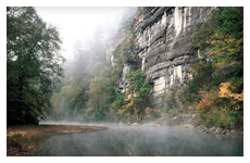
 The Buffalo River National Park is home to one of the few remaining free flowing rivers in America, one of the tallest waterfalls in the Midwest, and over 400 elk. Flowing for over 132 miles, America’s First National River pours over rapids and through multicolored steep bluffs cutting through tree-covered banks concealing over 100 miles of serene trails. Wildlife, outdoor adventure, scenic vistas, and pioneer homesteads abound.
Hike in the the Buffalo River National Park Region.
Watch the sun rise or set in the park and catch a glimpse of the elk in Boxley Valley (Highway 21 S at Highway 43) during early morning and late evening. Visit the Ponca Elk Education Center to learn more.
Stop at the Jasper Square for an old fashioned soda at The Ozark Café. Chat with a local or look through old photographs and newspapers like people have been doing here for over 100 years. If your timing is right, you just might hear some fiddle music played by local musicians.
As you follow Scenic 7 Byway to its highest point you will want to stop to see the “Arkansas Grand Canyon” before heading to Harrison.
GPS is very unreliable in this area so printed maps are recommended for navigation when exploring areas off of the Arkansas Art Trail. The National Park Service provides detailed maps of the Upper, Middle, and Lower Buffalo River National Park. Consult the National Park Website or guidebooks written by local outdoor enthusiast to plan your trip through the Buffalo River National Park.
Dr. Neil Compton and Congressman John Paul Hammerschmidt were instrumental in saving the Buffalo National River. Learn more about these men while visiting Bentonville.
Guidebooks by local writer and photographer Tim Ernst are a reliable resource for hiking the Buffalo River National Park.


Comments are closed.